LIFE
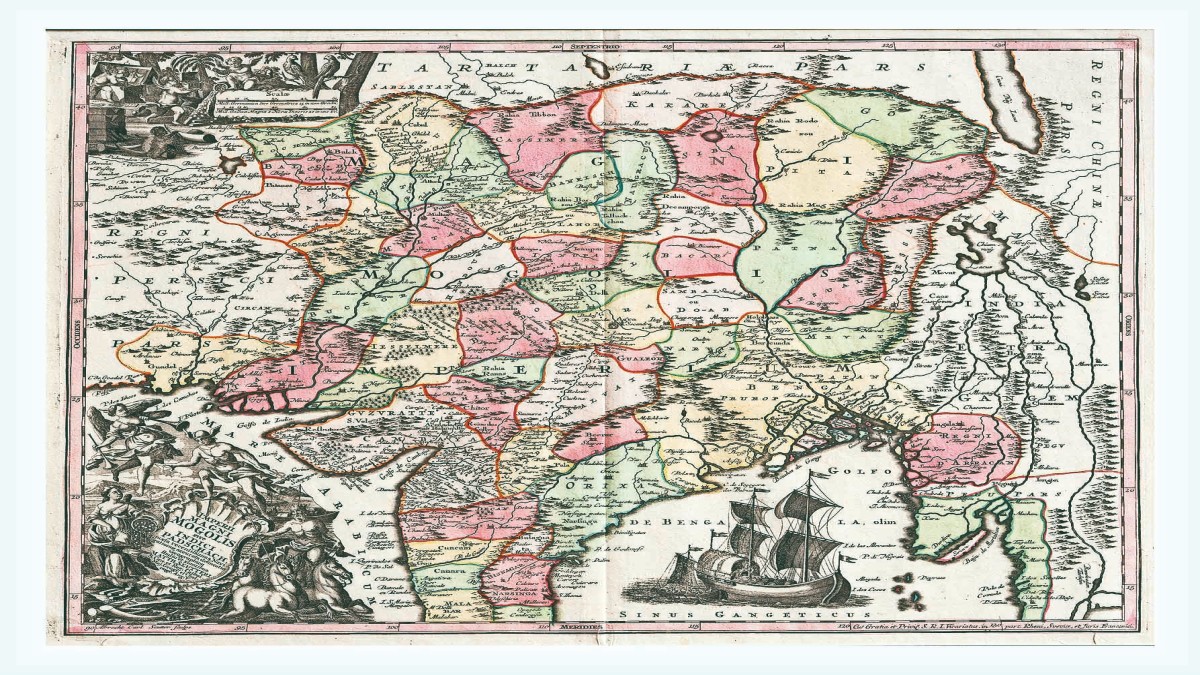
More than two centuries ago, English geographer James Rennell printed a map that showed the course of the Ganges from Haridwar to the Bay of Bengal. Working for the East India Company, Rennell had set forth to find a waterway from the then Calcutta to the north of India. The map he made in 1786 with a cartouche showing a native man bowing before the crown of the British empire would hugely benefit the East India Company’s trade through the newly discovered route and go on to aid the colonisation of the country. The map of Major Rennell, a Surveyor General of Bengal for the East India Company in the later period of the 18th century, is part of a new exhibition portraying the roller-coaster journey of the subcontinent over four critical centuries. Cartographical Tales: India Through Maps, which opened at the Ojas Art gallery near the Qutab Minar in the national capital on August 2 and will continue till September 22, stitches together a significant period in the history of the subcontinent. Coinciding with the 78th anniversary of India’s independence, the exhibition has 78 maps from such famous cartographic publishers of the times as Rennell, his compatriot John Tallis, Pierre Mortier, Rigobert Bonne and Pierre M Lapie of France and Matthäus Seutter of Germany. Printed in countries like England , Austria, Germany, France and Italy, the maps mounted at the Ojas Art gallery travel back to the 15th century and retrace the history of the next four centuries. The earliest map, Table of Asia, was printed in Venice in 1598, with the newest relating to 1946. “The maps spanning four centuries reflect the change in the Indian subcontinent over this important period,” says Anubhav Nath, the director of Ojas Art. “The maps were commissioned by the British or the Portuguese government and these served practical purposes,” adds Nath referring to the needs of colonial powers like the waterway mapped by Rennell for the East India Company in 1786. “Especially for the British, making maps was a practical need.” Collected over two decades, the maps of Cartographical Tales rampantly exhibit the hegemony of the coloniser. “The English maps always glorified the British by showing the supremacy of the empire,” explains Nath, who presented his collection of maps for the first time in an exhibition, India: The Mapful Story, at the Ojas Art gallery five years ago. Among the maps are Peninsula Indiae Malabar Coromandel Ceylon by German engraver Johann Baptist Homann published in 1736—12 years after his death, Neueste Karte Von Hindostan (1788), a rendition of Rennell’s original Map of Hindoostan (1782) by Austrian cartographer Franz Anton Schrämbl, and a scarce map by Seutter extending from India to Australia published in 1730. Cartography, the art of making maps, is believed to have originated in ancient Greece. The Romans used maps to help in their military victories, a strategy that was quickly adopted by the rulers that came after. Cartography gained prominence as a science in the 16th century with the publication of a world map in 1659 by Flemish cartographer Gerardus Mercator . “Cartography, the art of depicting geographical areas, peaked during the 17th-19th centuries as explorers charted new territories and accurately marked locations using longitudes and latitudes. This period saw extensive commissioning of maps by Western powers,” says Nath. “With boundaries becoming more and more pronounced as countries fight over territorial integrity, maps of the past and the stories they tell are more relevant today than before,” he adds. “India’s geography has been shaped over centuries and these maps narrate stories that transcend their intricate demarcations. Each of these rare maps helps people relate to an era or period through their intricate geographical enunciations and altering boundaries that they represent. One tends to discover something new in the same map on a daily basis,” says Nath. One of the highlights of the exhibition is a 1687 map made by the Wagner cartography company in Germany, which shows territories under the Mughal empire with an illustration of the Red Fort to mark the 50th anniversary of its construction. Another is a 1672 map of Goa with a cartouche identifying 43 buildings and an illustration that includes the harbour full of ships and two elephants engaging in labour. Faizal Khan is a freelancer. Get live Share Market updates, Stock Market Quotes , and the latest India News … Read More and business news on Financial Express. Download the Financial Express App for the latest finance news. None


What’s New


Spotlight


Advertisement


Featured News


Latest From This Week


Popular News